It is formed mainly
by weathering and erosion.
by
Dr. Nitish Priyadarshi
Geologist.
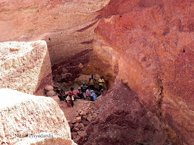
Above pictures are of Dome gneiss hill. This typical
dome-gneiss (locally known as dongris) 26 km from Ranchi on Ranchi-Bundu highway (850 27”
longitude and 230 14” latitude) has slopes on all
sides (the average inclination being about 40 degree to 50 degree). There is
little soil but oozing moisture from rock foliae supports tuft grass except the
entirely bare rocky surfaces.
A dome is a curved formation or structure. It is shaped like
half of a sphere. Imagine cutting an orange in half, and placing it
cut-side-down on a table. This is the shape of a dome, although most domes in
nature are not perfectly rounded.
Some natural domes develop when magma from deep within the Earth pushes up surface rock layers. This type of geologic dome can form as magma intrudes between two layers of sedimentary rock. The magma creates a dome or triangle shape as it pushes the other layers apart. The hardened magma that forms this type of dome is called laccolith.
Another kind of dome is shaped primarily by weathering and erosion, which cause curved sheets of rock to separate from a large rock mass.
The dome shaped hill near Ranchi is formed mainly by weathering and
erosion.
The Chotanagpur plateau region is made up mainly of
Precambrian rocks but has witnessed uplifts synchronously with the Himalayan
uplift in the Cenozoic. Chotanagpur plateau of Jharkhand is quoted as a typical
example of domal plateau because it is studded with numerous batholithic domes
which were intruded in the Dharwarian sedimentaries during Archaean period.
Prolonged denudation has removed the superincumbent Dharwarian covers and these
batholithic domes have been exposed on the surface.
The European geographers who attended the ‘symposium on
erosion surface’ in 1968 at Ranchi
felt that Chotanagpur was a fossil or dead erosion surface. There were
pediments in the region during the past more arid climate. Now the climate had
changed to more humid one. This has caused so much production of weathered
waste in conjunction with hot climate, that the sediments were more than what
could be cleared by the transporting process (mainly running water). Thus the
earlier pediments and bedrock were concealed under the debris and sediment.


