Sunday, August 30, 2015

A visit to Barabar caves near Gaya in Bihar, India.


Dr. Nitish Priyadarshi


Caves of Barabar hills near Gaya.


A visit to Barabar caves near Gaya in Bihar, which is an isolated location away from the mainstream, makes one imagine the activities at the place in ancient times, as the abode of the mendicants. Not much seems to have changed in the timeline of history, if one spends some time to meditate inside the caves which still bear the Mauryan Polish in a way as if it had been polished just yesterday. Several inscriptions are to be seen on the caves. The Hills have always remained mysterious and convey a spiritual reverberation.

The Hills were first excavated for the Ajivikas during the reign of Asoka and were occupied during the following centuries by different groups of sages and mendicants.

I visited the Hills at Barabar in August, 2015 during my way back to Ranchi from Patna. About 40 kilometers  to the north of Gaya in Bihar, near Belaganj, there are several groups of granite hills, called Kauwa-Dol, Barabar, Nagarjuni and Dharawat. All of these possess several remains of the ancient times. The caves in the Barabar hills are usually known as the Sapt-griha or sat-ghara.

A cave is a naturally occurring hollow area inside the earth or in the hills. Most caves are formed by some type of erosional process and also man made. The most notable exception is hollow lava tubes such as those in Hawaii. The formation of caves depends upon geologic, topographic, and hydrologic factors. These factors determine where and how caves develop, as well as their structure and shape. The study of caves is called speleology. Some caves may be small hillside openings, while others consist of large chambers and interconnecting tunnels and mazes. Openings to the surface may be large gaping holes or small crevices.
Caves have provided shelter to prehistoric, ancient, and primitive contemporary people such as the Tasadays of the Philippine Islands. Human remains, artifacts, sculptures, and drawings found in caves have aided archeologists to learn about early humans. Caves are sites of many important archeological discoveries such as The Dead Sea Scrolls. Many religious traditions have regarded caves as sacred and have used them to perform rituals, ceremonies, and sacrifices. Some ancient traditions felt that caves led to the underworld. Caves have fascinated poets, artists, philosophers, and musicians.
In ancient days human made caves in Basalt rocks and granite rocks for their personal use.


Rock-cut excavations represent an aspect in Indian architecture that has its origin in the Mauryan period in about third century B.C. and the earliest extant examples are known from Bihar at Barabar and Nagarjuni Hills in Gaya district near Makhdumpur block. There we have group of caves, which are attributed to Asoka and his grandson Dasaratha. This tradition flourished in the subsequent periods chiefly in western India and little is known of their existence elsewhere.

These are one of the oldest surviving rock cut caves. The caves are present on the twin hills of Nagarjuni and Barabar. Studies have shown that these caves date back to the 3rd century BC, during the reign of the Mauryas. The caves were used by ascetics belonging to the Ajivika sect -  Another system in the Indian Philosophy. Ajivika (Ājīvika) is one of the nāstika or "heterodox" schools of Indian philosophy. Founded in the 5th century BCE by Makkhali Gosala. Both Jaina and Buddhist texts state that Ājīvikas believed in absolute determinism, absence of free will, and called this as niyati. Everything in human life and universe, according to Ajivikas, was pre-determined, operating out of cosmic principles, and true choice did not exist. Archaeologists have  claimed that ascetics known as Ajivikas used Barabar and Nagarjuna caves in Jehanabad district to practise ritualistic deaths at the time of Emperor Asoka and thereafter.

There are two human structure carved on the rocks near by which does not resembles to modern human beings.

Hills around the barabar caves are highly weathered. They are of granite rocks. In earlier days geology and rock types  played major role in carving caves by ancient civilization.

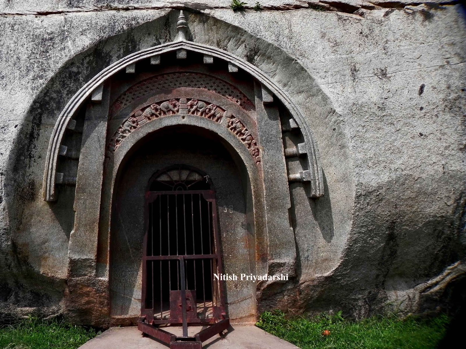
These caves are usually double chambered and made of granite with the internal surface being highly polished, resulting in an echo effect. The first chamber was bigger and probably this was where the worshipers congregated. The second adjoining chamber was built smaller and must have been used as a place to worship. There are four such caves on the Barabal hill, of which the Lomas Rishi caves and the Sudama caves can be counted as the most ancient examples of ancient rock cut architecture. The architecture typically used huge archways, which was not a common style, as far as ancient architecture is concerned.

They are dark caves. Even when they open towards the sun, very little light penetrates down the entrance tunnel into the circular chamber. There is little to see, and no eye to see it, until the visitor arrives for his five minutes, and strikes a match. The walls of the circular chamber have been most marvelously polished.


Inside view of the cave.Polish on the walls.


Human structure carved on the rock.


Highly weathered hills.

Monday, July 13, 2015

Is Bihar State of India prepared for the disaster?


The state of Bihar has been facing floods since for a long time.

By
Dr. Nitish Priyadarshi

Bihar is India's most flood-prone State, with 76% of the population in the north Bihar living under the recurring threat of flood devastation. According to some historical data, 16.5% of the total flood affected area in India is located in Bihar while 22.1% of the flood affected population in India lives in Bihar. About 68,800 square kilometres (26,600 sq mi) out of total geographical area of 94,160 square kilometres (36,360 sq mi) comprising 73.06% is flood affected.

Geographically Nepal is a mountainous region. When heavy rains occur in the mountains of central and eastern Nepal the water flows into the major drainages of Narayani, Bagmati, and Koshi rivers. As these rivers cross into India they flow into the plains and lowlands of Bihar and break their banks.

Bihar is surrounded by Nepal in the north, West Bengal in the east, Uttar Pradesh in the west and  Jharkhand towards the south. There are several rivers that run through the state: Ganga, Sone, Punpun, Falgu, Karmanasa, Durgavati, Kosi, Gandak and the Ghaghara, to name a few. Nearly 85% of the state’s land is under cultivation. Bihar also receives heavy rainfall all through June to October.

The state of Bihar has been facing floods since for a long time. It accounts for almost half of India’s average annual flood losses. In the year 1914, Bengal and Bihar faced floods. In the year 1934, Bihar was shaken by an earthquake which was again followed by floods.

The state has been facing floods ever since, but the frequency of floods has become high in recent years. There have been floods almost every year from 1979 which have caused extensive damage. Lakhs of people have lost their lives and their homes. The state has faced infrastructural losses worth crores of rupees.

The state government has built about 3000 kms of embankments, but the flow of the river has grown 2.5 times resulting in the failure of embankments in every flood.

So the big question is: is the state of Bihar prepared? The Disaster Management Department, Government of Bihar has come out with a number of schemes.
  • Procurement of motor boats and other necessary accessories like life jackets, mahajals, tents, etc. for 28 flood-prone districts.
  • To improve the response mechanism and tackle the impact of natural disasters effectively, a State Disaster Response Force (SDRF) is to be established on the similar pattern of National Disaster Response Force (NDRF).
  • A number of warehouses will be constructed to store the relief and rescue materials and to keep them safe and secure.
  • Establishment of Emergency Operation Centres (EOC) in all the districts to carry out rescue and relief work effectively.
  • Since the communication system often becomes dysfunctional, procurement and proper maintenance of communication systems has been taken into account. Satellite phones, GPS instruments, hand packs, walkie – talkies will be procured.
  • An Early Disaster Warning System is to be established.
  • A plan has been prepared to generate awareness among the masses about the ways and means of mitigating the risk of disaster.
The budget for the above scheme crosses 5000 crores.

What more can be done?

A number of structural measures can be taken up in the state:
  • Detention Basins: The state area has a number of depressions locally called chaurs which act as detention basins. These chaurs absorb a considerable amount of water of the first flood of the season. No man made detention basins or improvements in natural chaurs has been done.
  • Embankments: All the rivers have been embanked in the state. River Kosi is embanked on both the sides. But there are few gaps in these embankments which reduce its effectiveness. The maintenance and repair of these embankments must be taken into account.
  • Afforestation in the catchment area for absorption of rain water.
  • Channel improvement works increasing the discharge capacity of the river.

Waste Management in Bihar.


Waste management is the process of treating solid wastes and offers variety of solutions for recycling items that don’t belong to trash. It is about how garbage can be used as a valuable resource. Waste management is something that each and every household and business owner in the world needs.

Methods of Waste Disposal which can be adopted in Bihar.

Landfill

The Landfill is the most popularly used method of waste disposal used today. This process of waste disposal focuses attention on burying the waste in the land. Landfills are found in all areas. There is a process used that eliminates the odors and dangers of waste before it is placed into the ground.

Incineration/Combustion

Incineration or combustion is a type disposal method in which municipal solid wastes are burned at high temperatures so as as to convert them into residue and gaseous products. The biggest advantage of this type of method is that it can reduce the volume of solid waste to 20 to 30 percent of the original volume, decreases the space they take up and reduce the stress on landfills.

Recovery and Recycling

Resource recovery is the process of taking useful discarded items for a specific next use. These discarded items are then processed to extract or recover materials and resources or convert them to energy in the form of useable heat, electricity or fuel.

Composting

Composting is a easy and natural bio-degradation process that takes organic wastes i.e. remains of plants and garden and kitchen waste and turns into nutrient rich food for your plants. Composting, normally used for organic farming, occurs by allowing organic materials to sit in one place for months until microbes decompose it. Composting is one of the best method of waste disposal as it can turn unsafe organic products into safe compost. On the other side, it is slow process and takes lot of space.
Hospital Wastes Management.
Hospital wastes have always been considered as potentially hazardous in view of the inherent potential for dissemination of infection. The major identified hazard was that of infection, because over millennia communicable diseases had been the most common cause of morbidity and mortality in the community and majority of persons receiving treatment in the hospitals were suffering from communicable diseases. Disinfecting right at source and disposal by incineration, which completely destroys micro-organism of all types, has been the time tested and most widely advocated method for safe management of hospital waste.


Solid Waste Mismanagement in Patna

1. Prohibit littering on the streets by ensuring storage of waste at source in two bins; one for biodegradable waste and another for recyclable material.
2. Primary collection of biodegradable and non-biodegradable waste from the doorstep, (including slums and squatter areas) at pre-informed timings on a day-to-day basis using containerized tricycle/handcarts/pick up vans.
3. Street sweeping covering all the residential and commercial areas on all the days of the year irrespective of Sundays and public holidays. Abolition of open waste storage depots, and provision of covered containers or closed body waste storage depots.
5. Transportation of waste in covered vehicles on a day to day basis.
6. Treatment of biodegradable waste using composting or waste to energy technologies meeting the standards laid down.
7. Minimize the waste going to the land fill and dispose of only rejects from the treatment plants and inert material at the landfills as per the standards laid down in the rules.

Friday, May 1, 2015

10 quakes in 18 years in J'khand, claims geologist

10 quakes in 18 years in J'khand, claims geologist

Jharkhand has experienced more than 10 tremors in 18 years though their intensity was mild to medium, geologist Nitish Priyadarshi claimed and suggested that newly constructed buildings in the state should be earthquake-resistant.

'Back-to-back tremors occurred for the first time in Jharkhand. The state has never experienced aftershocks,"Priyadarshi, a member of the Geological Society of India, said here.
   
He said the Chhotanagpur Plateau in Jharkhand represents a part of the Indian Peninsular field that is "stable cratonic block of the earth crust".
   
Craton is the stable interior portion of a continent characteristically composed of ancient crystalline basement
rock and there is a belief that land above a cratonic block is generally shielded from earthquakes.
   
"The cause for concern is that there had been more than 10 mild to medium tremors occurred in the area since 1997," said Priyadarshi.
   
"So, all the new buildings coming up in Chhotanagpur Plateau should be earthquake resistant," he said and suggested that with the consent of owners dilapidated buildings should be demolished to pave way for earth-quake resistant buildings.
 "Two types of effects occur in the Chhotanagpur plateau. The first is sympathiser (the effect following
tremors happening outside the region) and the second is localised following stress and strain in the rocks.
   
"Tremors in this plateau are shallow, usually shaking between a magnitude between one and 5 on the Richter scale and happening in less than 15 miles deep. These tremors happen randomly and are unpredictable," he added.
   
Quoting a 2002 report from the Bureau of Indian Standards, he said Jamshedpur and Chaibasa come in Seismic zone-2, Ranchi and Hazaribagh Zone 3 and the Santhal Pargana in Zone-4.

"Major tremor expected anytime, not possible to predict exact time," says geologist , AniNews.in

"Major tremor expected anytime, not possible to predict exact time," says geologist , AniNews.in


Ranchi, Apr. 27 (ANI): Geologist Nitish Priyadarshi has stated that another major tremor can be expected anytime and the countries near the Himalayan region should be on high alert.
"Major tremor can occur anytime, maybe in a week or two.It is not possible to predict the exact time. Countries near the Himalayan region like Afghanistan, Nepal, India and Pakistan should be on high alert," Nitish Priyadarshi told ANI here.


Priyadarshi asserted that the earthquake was triggered by natural phenomenon and anthropogenic activities as well.
"The main reason for this earthquake is tectonic movements, the plates are colliding with each other, below the Himalayas. Also, the huge blasting which is going on in Himalayas to make roads is impacting the rocks in the Himalayas. This earthquake is trigged by natural phenomenon and anthropogenic activities as well," he added.