Wednesday, October 16, 2013

Impact of Phailin cyclone in Ranchi city of India.


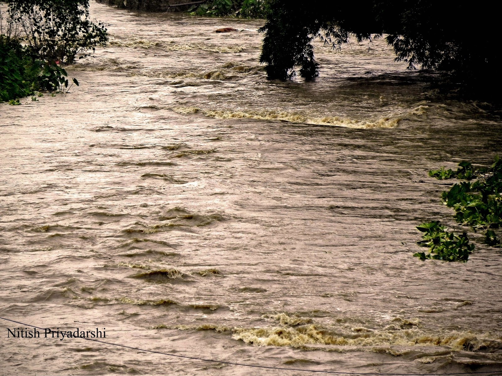
Rivers were overflowing and trees were uprooted.

By

Dr. Nitish Priyadarshi.

Heavy rains on Sunday (13th Otober) lashed Jharkhand following the "peripheral effect" of cyclone Phailin. The peripheral effect following Phailin that lay centred in Odisha began in Jharkhand since early morning with heavy rains lashing several districts of the state.74.6 mm rain was recorded in Ranchi till 8.30 am. Phailin entered Jharkhand on Sunday around 4am causing heavy rainfall and recorded wind speed of up to 40kmph. Ranchi recorded 117mm rainfall from Sunday 4am till Tuesday morning. Most of the small rivers of Ranchi like Harmu River, Jumar River, Potpoto River, River flowing under the Over bridge etc. were overflowing due to heavy rain in the city. Even many of the local ponds were overflowing. Trees were uprooted and low land area faced water logging.  

Pictures below show the some of the impact of Phailin in Ranchi city. 


                  Clouds gathering on evening of 12th October.


                Trees uprooted due to storm and heavy rain.

                                 Trees uprooted in busiest road of Ranchi city.


                                          Empty road.

                                                       Overflowing pond.


                                            Overflowing river.


Thursday, September 19, 2013

Chemical Warfare is another threat to the environment.

Its impact is nearly everlasting.

By

Dr. Nitish Priyadarshi

Earlier it was controversial report of use of the Depleted Uranium where thousands and thousands of people, including many children, died after the war in Bosnia from the use of depleted uranium projectiles. Completely healthy people who have lived or are still living in locations were targeted missiles out of the blue they got cancer or leukemia and after a longer or shorter disease died. Depleted uranium has been used in at least the last four wars Gulf War 1, Bosnia and Kosovo in the Balkans, Afghanistan and Gulf War 2. The last two of the four wars, took place in 2001 (Afghanistan) and 2003 (Iraq).

Now the latest news is about use of other weapon of mass destruction on the humans. According to UN report there is “clear and convincing evidence” that chemical weapons were used in the August 21 attack in Syria. The conclusion is that chemical weapons have been used in the ongoing conflict between the parties in the Syrian Arab Republic, also against civilians, including children, on a relatively large scale.

The environmental, chemical and medical samples collected provide clear and convincing evidence that surface-to-surface rockets containing the nerve agent Sarin were used in the Ghouta area of Damascus.
The report said surface-to-air rockets containing the nerve gas sarin were used in Ein Tarma, Moadamiyan and Zamalka in the Ghouta area of Damascus. It does not say which parties in the conflict used the weapons.
Rockets and fragments were found to contain sarin. Several surface-to-surface rockets capable of delivering significant chemical payloads were identified and recorded at the investigated sites.

Close to the impact sites, in the area where people were affected, inspectors collected 30 soil and environmental samples — far more than any previous U.N. investigation — and in a majority of the samples, "the environment was found to be contaminated by sarin," its by-products, and "other relevant chemicals, such as stabilizers."

Blood, urine and hair samples from 34 patients who had signs of poisoning by a chemical compound provided "definitive evidence of exposure to Sarin by almost all of the survivors assessed."
Sarin,  is an organophosphorus compound with the formula . It is a colorless, odorless liquid, used as a chemical weapon owing to its extreme potency as a nerve agent. It has been classified as a weapon of mass destruction in UN Resolution 687

Sarin can be lethal even at very low concentrations, with death following within one minute after direct ingestion due to suffocation from lung muscle paralysis, unless some antidotes, typically atropine or Biperiden and pralidoxime, are quickly administered to a person. People who absorb a non-lethal dose, but do not receive immediate medical treatment, may suffer permanent neurological damage. Like other nerve agents, sarin attacks the nervous system by stopping nerve endings in muscles from switching off. Death will usually occur as a result of asphyxia due to the inability to control the muscles involved in breathing function.

There are so many issues facing the world today that it is sometimes hard to understand why they occur and what they affect.   Today it is apparent that many people take the environment of the earth for granted.   Pollution, energy, and natural resources are all seen as an environmental element that can threaten our future and destroy the environment.   But there is another threat to the environment that is certainly overlooked by today's society and was overlooked by many in the past.   This element is the act of war.   There are many different aspects of war that can affect the environment and the people of our world, but there is one specific facet of war that could be considered most detrimental… chemical warfare.   "Chemical warfare is warfare (and associated military operations) using the toxic properties of chemical substances to kill, injure or incapacitate the enemy" (Chemical Warfare). Chemical weapons can be widely dispersed in gas, liquid and solid forms and may easily afflict others than the intended targets. Nerve gas and tear gas are two modern examples.  But not only does it leave its mark on society and the people of the world, chemical warfare can destroy the unique qualities of nature as well.   The practice of chemical warfare dates back to 1000 B.C and is still used today.   Its impact is nearly everlasting, but still so many people are uneducated on its effects. These weapons kill everyone in any environment where they're deployed. Historically, chemical weapons are inhumane and a horrific way to die—and that's why the most of the world has outlawed them. Chemical warfare is a critical issue of today's society and needs to be dealt with because of its severe impact on our environment and the people of the world.

Earlier one case of such disaster was reported from Vietnam War where approximately 19 million gallons of Agent Orange were used by the US military in southern Vietnam between 1962 and 1971. An aggressive herbicide which defoliates trees, it was used on a large scale in Vietnam’s jungles to enable US troops to spot Communist troops more easily. It eradicated around 15% of South Vietnam’s vegetation, and gave rise to serious health problems for the soldiers, civilians and local wildlife that were exposed to it. Agent Orange contains dioxin, a highly toxic substance that is still detected in the bodies of Vietnamese people today. It contaminated the soil and rivers and, through the food chain, passed into fish - a staple of the Vietnamese diet.

Depleted uranium (DU) is easily ingested by humans because it turns into radioactive dust on impact. As a result, hundreds of thousands of civilians and soldiers have been exposed to a highly toxic, radioactive substance and have suffered the numerous effects of this. In fact, the World Health Organisation suggests that young children in particular are at great risk because “typical hand-to-mouth activity of inquisitive play could lead to high DU ingestion from contaminated soil.” At least 600,000 pounds of DU and uranium dust were left in the Middle East after the Gulf War. With a half-life of 4.5 billion years, the health effects of DU will be a long-term problem.
CW can have very different effects on health. They are grouped in four categories:
1.      Blister Agents (cause severe skin, eye and mucosal pain and irritation as well as burns)
2.      2. Nerve Agents (disrupt the mechanism by which nerves transfer messages to organs and may lead to death by asphyxiation as control is lost over respiratory muscles)
3.      Choking Agents (cause a build-up of fluids in the lungs which then leads to suffocation)
4.      Blood Agents (affect the body by being absorbed into the blood and cause death      in a matter of minutes through respiratory failure)

The Issue of Depleted Uranium (DU) and Chemical weapons are extraordinarily important. It represents a clear threat to the health of all humanity, and all life forms on planet Earth. Scientists, medical professionals, war veterans, active duty personnel, international lawyers and the global human community must call for awareness of this crisis and simply to stop the use of weapons of mass destruction, in order to preserve life on the planet.

Reference:
http://www.ipb.org/web/index.php?mostra=content&menu=Weapons%20and%20their%20impacts%20on%20communities&submenu=Chemical%20Weapons
http://news.nationalgeographic.com/news/2013/08/130828-chemical-weapons-syria-attack-military-action-science-world/

Saturday, September 14, 2013

Geological evidences of ancient glaciation in Jharkhand State of India.


Permo-Carboniferous time, about 300 million years ago, was a period of great glaciation.
By
Dr. Nitish Priyadarshi
Geologist


The Earth has a history of climate change. There have been ice ages and super-volcanoes and with them came evolutionary changes in many of the Earth’s inhabitants;

A glacial period (or alternatively glacial or glaciation) is an interval of time (thousands of years) within an ice age that is marked by colder temperatures and glacier advances. There have been five known ice ages  in the Earth's history, with the Earth experiencing the Quaternary Ice Age during the present time. Within ice ages, there exist periods of more severe glacial conditions and more temperate referred to as glacial periods and interglacial periods, respectively. The Earth is currently in an interglacial period of the Quaternary Ice Age, with the last glacial period of the Quaternary having ended approximately 10,000 years ago with the start of the Holocene epoch.

The Permo-Carboniferous refers to the time period including the latter parts of the Carboniferous and early part of the Permian period. Permo-Carboniferous rocks are in places not differentiated because of the presence of transitional fossils, and also where no conspicuous stratigraphic break is present.

Permo-Carboniferous time, about 300 million years ago, was a period of great glaciation. The widespread distribution of Permo-Carboniferous glacial sediments in South America, Africa, Madagascar, Arabia, India, Antarctica and Australia was one of the major pieces of evidence for the theory of continental drift and led ultimately to the concept of a super-continent, Pangaea. Glacial activity spanned virtually the whole of Carboniferous and Early Permian time . Toward the end of the Carboniferous, around 290 million years ago, Gondwana, the southern part of Pangaea, was located near the south pole. Glacial centres expanded across the continents, producing glacial tillites and striations in pre-existing rocks.

The Late Carboniferous and Early Permian period was an exceptional phase in the earth’s history when the precursors of the modern continents were assembled in the form of two big landmasses (Gondwana and Laurasia) which were connected to form a supercontinent (Pangaea) such that the major part of the land area was in the southern hemisphere. Since the Earth’s climate is dependent on land and ocean distribution, the global air circulation and climate were radically different from the present.


Past Glaciation evidence in Jharkhand State.


Rocks of glacial derivation are limited to the Talchir Formation at the base of Gondwana supergroup. The Talchir, all over Peninsular India comprises a variety of rock types including diamictite (tillite), conglomerate, sandstone, laminated varve-like shale-siltstone (rhythmite facies), and locally turbide deposits. The maximum known thickness is seldom in excess of 300 m.

The sediments comprising the Talchir Formation contain records of a chain of events caused by the climatic evolution during the Carboniferous–Permian boundary period in India. The occurrence of a boulder bed derived from a glacial moraine at the base of the Talchir Formation indicates presence of glacier ice near the basin periphery. Subsequent occurrence of sandstone–siltstone beds and their sedimentary features signify evolution of a large water body. Different research work suggests that the water of this basin was supplied by melting of the glacier. The glacier later retreated far from the lake margin when sediments were carried by melt-water streams.

This development marks a relatively rapid warming episode, which reached a climax when waves generated by intense storms created hummocky cross-stratification in the sedimentary layers. Several Gondwana basins in east-central India recorded this climatic transition in the basal part of their sedimentary sequence typified by the Talchir Formation. The warming initiated during late Talchir continued for a geologically long time with substantial melting of ice in various regions leading to increase in sea level as evidenced by signature of marine transgressions (at Umaria, Manendragarh and Daltonganj). This chain of events finally culminated in occurrence of widespread vegetation and swampy land, which formed the massive Permian coal deposits of eastern India.

Damodar Valley basin in Jharkhand State contains a chain of sub-basins containing a complete stratigraphic sequence of Talchir sediments(Ghosh and Mitra,1975). An excellent exposure occurs near the confluence of Dudhi Nala, Dube Nala, and Silai Nala about 0.5 km south of the village Jarwa  in the western part of the Bokaro sub-basin.

East Bokaro coalfield:

The East Bokaro coalfield ranks third amongst Indian coalfields in the respect of coal potentiality. The name of the Bokaro field was given by D.H. Williams in 1846-47 as the Bokaro river flows through the field for nearly 40 km.

The Talchir formation crops out only in the north-eastern periphery around Chapri. The Talchir formation has its base the typical tillite, which crops out in the nala (rivulet) south east of Lakarkatwatoli village. The tillite is practically unstratified and devoid of sandy interbands. It usually attains a thickness of 2m to 3m. the till favbric study in the Chapri area indicates that the inflow at the dawn of Gondwana sedimentation was from WNW to ESE. It is therefore evident that the Precambrian upland lying to the north of East Bokaro coalfield was the main gathering ground of ice.

Because of the restricted distribution of Talchir beds in the vicinity of Chapri it is surmised that only one major lobe of ice advanced into the eastern periphery of the coalfield.

West Bokaro coalfield :

The base of Gondwana sequence is marked by a thick pile of glacial and periglacial deposits of Talchir Formation. The Talchir beds are well exposed in the western part of the coalfield to the east and northwest of Mandu in Hazaribag district and also occur as a lenticular patch north of Tapin. The Talchir formation comprises diamictites, sandstones, shales, turbidites and rhythmites, which are all typified by a khaki green colour. This section lies at a distance of 68 km, from Ranchi. The area of study lies at a distance of nearly 3 km from Mandu, off the west side of the Dudhi bridge.

Characteristic features of glacial transport are observed in the forms of polished and striated boulders. Unsorted nature of the deposit also suggests their glacial origin.

Ramgarh Coalfield:

The Talchir rocks are best developed in the northern part of the basin around the Barki Punu. A narrow strip of such rocks is also exposed all along the eastern periphery of the basin where good exposures are present in the Bhera river near famous Rajrappa temple.

Till fabric analysis of the basal tillites in the Barki Punu area has indicates glacial transport from WNW to ESE which is compatible with ice flow directions from equivalent horizons in the adjoining Karanpura and Bokaro basins (Ghosh and Mitra,1975).

North Karanpura Coalfield:

The North Karanpura coalfield which is the western most member in the east-west chain of the Damodar valley basins forms a large expanse of coal bearing sediments spread over Hazaribag, Ranchi and Palamau districts.
Talchir formation is exposed along the fringes of the basin in the north, east and south. Tillite which is dumped type deposit comprises out sized clasts, which vary in size from a few centimeters to a few meters.

The different occurrences of the tillites indicate that they were laid down by different lobes of valley glaciers as abalation till or lodgment till rather than by a continuous ice sheet (De, !980).

Glacial pavements with undisputed glacial striae indicating ice transport from north and NW has been reported from the north of Pakri Barwadih at the northern margin of the basin ( Chakraborty and Bhattacharya, 1973).

Auranga Coalfield:

Auranga coalfield is the easternmost of the North Koel valley Gondwana basins. It is only 8 km away from the North Karanpura basin, the westernmost of the Damodar Valley coalfields.

The Talchir formation in Auranga basin has a maximum thickness of 30 m to 35 m. It is evident the ice had moved from the southern uplands and deposited the morainic material in bedrock depression. From the distribution pattern and their facies organization, it can be concluded that several lobes of ice had reached this basin and deposited glacial and fluvioglacial sediments in the bedrock depressions.

Hutar coalfield:

The Hutar coalfield is the westernmost of the Damodar-Koel valley Gondwana basins. It is one of the four coal bearing areas in Palamau district of Jharkhand.

The Talchir sediments in this area exposed along the northern, south eastern and southern boundaries of the Hutar basin and they crop out as narrow strips. Good exposure of Talchir rocks are observed in the section of nalas (rivulets) like the Saphi nala near Unkamanr, the Deori nala west of Barwadih and near Paisartanr, the Baheradhora nala, the Thongwa nala, tributaries of the Saphi nala around Nawadih, the Jamtipani nala and its tributaries and a tributary of the Jharna nala.

An analysis of till fabric, primary directional structures and lithofacial distribution indicates that the direction of glacial transport was mostly towards  north and north-east. Though no sub-surface information is available, total thickness of the Talchir formation is estimated to exist 50 m.

Deoghar Basins:

Extensive exposures of Talchir rocks are noted all along the southern margin of Jainti basin. The formation also covers a large area along the northern boundary of the Saharjuri and Kundit Kuraiah basins. In addition, more detached outliers of sediments have been recorded in the vicinity of Makranda, Alaura, Alakbera, Darabandh, Satuabad and Burhai. These occurrences of Talchir outliers testify to widespread glaciation in the Deoghar area, the detached outliers being erosional remnants.

Reference:

Chakraborti, S.K. and Bhattacharya, B.P. 1973: A note on the occurrence of glacial movements along the northern boundary of North Karanpura coalfield, Hazaribagh district, Bihar, Jour. Geol. Soc. Ind. 14(3).

Coal Resources of Bihar, 1987.  in Bulletins of the Geological Survey of India, Vol IV (part -1).

De, A.K. 1980: Lithology and conditions of deposition of Talchir Formation in North Karanpura Basin. Jour. Geol. Soc. Ind., Vol.21, 593-602.

Ghosh, P.K. & Mitra,  N.D. (1975): History of Talchir sedimentation in Damodar Valley Basins, Mem. Geol. Surv. Ind.,105.


Monday, July 29, 2013

Did India have the atomic power in ancient days?

 A small slide show on concept of atomic power of ancient India.
by
Dr. Nitish Priyadarshi


Our own culture, if we assume a starting point of 4000 B.C. has progressed from primitive agriculture and herding to nuclear fission is only 6,000 years. Considering the age of mankind, there has been ample time for other cultures to have arrived at a level roughly corresponding to ours. A re-examination of some of the ancient records that have come down to us might give some indication of man kind having previously attained our present aptitude for destruction. While there are hints of great blasting of the earth´s surface in the Bible (Sodom and Gomorrah), the Greek myths, and many of the legends of the Indians of North and South America, it is in the ancient records of India, copied and recopied from prehistoric antiquity, that we find, described in considerable detail, the use and effect of what closely resembles atomic explosions in warfare.


Unexpected references to such recent developments of our technological civilization are present in many of the ancient books of India, which, unlike so many records of the Western world, escaped burning and destruction.

These references deal, almost as if they were written today instead of thousands of years ago, with such matters as the relatively of time and space, cosmic rays, the law of gravity, radiation, the kinetic nature of energy, and the atomic theory.


Surprisingly modern-sounding references abound in the Mahabharata, a gigantic compendium of over 200,000 verses dealing with the creation of the cosmos, religion, prayers, customs, history, and legends about the gods and heroes of ancient India. It is supposed to have been originally written 3,500 years ago, but it refers to events that reputedly took place thousands of years before that. Among the verses of the Mahabharata, there are a number that contain vivid descriptions of what seem to be a firsthand view of atomic warfare.


Above film is a small slide show made by me on concept of atomic power in ancient India. I have gathered the information from different books and web sites. In this movie I have introduced new information from Jharkhand State of India which very few people know. I have not tried to prove any thing.

Monday, July 8, 2013

Impact of climate change on livelihood of the community in Pakur district, India.


Vulnerability assessment of the Pakur District of Jharkhand State in relation to climate change and its relevance to livelihood of the community and families.

By
Dr. Nitish Priyadarshi
Geologist.


              Small slide show on impact of climate change in Pakur.


        Agriculture production has reduced due to less or erratic rainfall.


                                    Forest cover has reduced.


                                         No green cover.


                                    Water level has reduced.


          Mahua production has also reduced due extensive heat.


                         Drought like situation exists for 4 to 6 months.


                             Scarcity of water in local ponds.


Introduction:

Climate change is a major challenge for agriculture, food security and rural livelihoods for billions of people including the poor. Agriculture is the sector most vulnerable to climate change due to its high dependence on climate and weather and because people involved in agriculture tend to be poorer compared with urban residents.

The climate change is already making impact on the lives of the population particularly the poor. It is already evident in number of ways. Consistent warming trends and more frequent and intense extreme weather events such as droughts, cyclones, floods, and hailstorms have been observed across India. The lives of the poor are punctuated by the risks and vulnerabilities that come with an uncertain climate.

Many believe agriculture is the most susceptible sector to climate change. This is attributed to the fact that climate change affects the two most important direct agricultural production inputs, precipitation and temperature. Climate change also indirectly affects agriculture by influencing emergence and distribution of crop pests and livestock diseases, exacerbating the frequency and distribution of adverse weather conditions, reducing water supplies and irrigation; and enhancing severity of soil erosion.

This study aims to answer questions: what is the trend of climate change in Pankur district, what is the impact on livelihood, who is vulnerable to the impact and why.

Background:

Pakur, famous for stone and Beedi (Biri) making industry, is one of the important revenue-earning districts of newly created Jharkhand State. Its black stone chips have got Asiatic fame in constructional qualities.

This district, once known for its thick & extensive forests, is now bereft of much of its jungle wealth. The medicinal plants such as Sarpgandha, Raigami or Dhami, Kazwa, Chiryaita etc. are now almost extinct. There has been large-scale destruction of forests in the past few years. So the Subsistent agro based economy, which was earlier supplemented by forest and forest produce, has been badly affected.

The survey was carried out in the seven villages of the Pankur district of Jharkhand State. They are Darajmath, Sangrampur, Pachaibera, Majdiha, Kalhajhur Sijua and Balidih.

The villages are surrounded by agricultural land, small hillocks which come under forest area. The agricultural land is badly eroded, unproductive red soil.

There are few small rivers and nalas running across these villages. They are the only source of irrigation for the field and are only supply water for the domestic needs such as washing, bathing and watering animals. Some of the villages do have a small village forest, which supply fuel and fodder  and other forest produce to the villagers.

General situation in this area is very difficult. Means of communication are very rare, roads are in poor condition. In rainy season people walk on foot for miles to reach market for purchasing article required for the family daily needs. 86% of the population is Santals and Paharias, and 12% are schedule caste, and other backward classes. There are some families who belong to business community commonly known as Mahajan and they are the one who more or less controls the economy of the area.

The Santals live in maculated villages surrounded by their fragmental holdings. The land and other properties are inherited by the male offspring. They live in thatch roofed mud house in symmetric rows lined on the both sides of the village main streets.

Traditionally, occupations are more or less divided among the men and women. Men plough the fields, thatch the root, while women gather firewood, cook, clean house, and raise the children.

Collection of Primary data:

Primary data on impact and vulnerability were collected by using group interviews in the villages from April 4 to 6, 2013. The interview was conducted in all seven villages. Early morning time was found to be an appropriate time. Discussion was also done by the animators.

Field observation:

Field observation was conducted in all the villages and photograph was taken regarding water level status.

Secondary data:

Relevant and available data were gathered from the office of a NGO Theodori Rural Development Project, Chandrapura, district Pakur.


Results and Analysis:

The climate change is already making impact on the lives of the population of the area. It is already evident in number of ways. The frequently experienced climatic shocks are prolonged drought and delay in the onset of rainy season, erratic and low precipitation, and heavy and unseasonal rainfalls. The interviewed villagers perceived the overall increasing temperature and downward trend of precipitation.

Drought or delay in the onset of rain land becomes dry and difficult to plough. Lack of precipitation hinders seed cultivation and germination of cultivated seeds. According to the villagers of Sijua agriculture has been worst affected from last five years due to decreasing and erratic trend of rainfall. Many Sal trees died due to extensive heat. Agriculture practice is stopped from February to June due to water scarcity. Remaining water is left for the use of livestock only. During this period villagers are forced to migrate to neighbouring state West Bengal as a lobourers for their earnings. They also carry their children which affects their study.

Accuracy in crop production has reduced. Profit from agriculture has also reduced, said villagers of Balidih. Villagers blame mass deforestation for climate change in the area.

Size of the wheat grain has reduced and also matures earlier. Size of the Papaya has also reduced. Earlier size use to be bigger, said villagers of Pachaibera.   

In the month of November 2012 when grains were ready for cutting heavy precipitation killed all the standing grains in the village of Majdiha.

A major source of income through Mahua ( Madhuca longifolia) tree has also reduced due to less production this year (2013). Mahua is considered sacred among the tribal people of the area because of the tree’s medicinal values. The flowers of the tree, which have a unique fragrance, are used to produce alcohol and provide livelihood to thousands of people. Villagers of Kalhajhur complained that insects and less rainfall are more destroying the plants. Previous years it was not so common.

Villagers of Darajmath complained that due to lack of sufficient rainfall and heat stroke, agricultural production has reduced drastically. To increase the production villagers have increased the use of fertilizers, which is also now affecting the quality of the soil.

Decline in agriculture has meant decline of agriculture work. There is little employment in the region outside of agriculture other than mining of Multani Soil (fuller's earth) in Sangrampur village or picking up waste coals from the road side which falls from the trucks carrying coals from coalmines to Pakur town.

Drought and delay in the onset of rain led to poor grass regeneration/ forage deficit, water shortage and heat stress on livestock, and consequently increased the mortality of livestock. Due to lack of food and water and decreasing grazing lands villagers either sold their livestock or they died. Situation was never worse like today, said many villagers.

With the available agricultural production data suggests climatic change has been frequently imposing challenge on their livelihood and consequently affecting the society’s socio-economic activity.

Soil erosion has also increased in the area visited due to erratic rainfall and increase runoff and less green cover.

All the interviewees reported the existence of repeated serious impacts on the society. They reported food deficits, educational hurdles (especially children), increased susceptibility to diseases and failure to fulfill financial requirements, and lack of agricultural input.

Few villagers suggested that women are more vulnerable to climate change. The vulnerability of women was explained from their confinement at home caring for children and family members, worry about feeding the family members and long distance travel to collect water and waiting long queues. In addition children are the other more vulnerable to the event. Vulnerability of children to climate crisis is apparent from long absence from school, prone to different diseases etc. Long distance travel to collect water with their mother is the main cause of delay or low class attendance. 

Effect on Water:

Many people from the region say that the rains are coming over a shorter period and the duration of precipitation is becoming erratic. If there  used to be monsoon over 90 days earlier, now it is raining fewer days, but in much sharper, more powerful bursts and with increasingly unpredictable patterns. As a consequence, water run–off increases and is highly varied in its availability. Less is stored and seeps into the ground, impacting underground aquifers adversely. Most of the wells and handpumps remain dry for four months (March to June). It affects the amount of water that rivers, ponds and streams receive in post-monsoon months. Villagers of the Kalhajhur said that the average water level has depleted from 20 to 25 feet. Handpumps work only in rainy season and dug wells are the only source but only for time beings. Dug wells are not working properly, complained the villagers of Majdiha and Balidih. They also said that from last few years they are facing erratic and less rainfall which has reduced their agricultural production.
In village Balidih earlier one rivulet use to fed water to the whole village but this year flow of water in this rivulet has decreased.

Since it is mostly women who do domestic work and get water, the water crisis has meant that women need to walk much longer distances to bring water. Even those handpumps that have water take much more time to bring up water during summer, because the pressure needed is higher, so they could be pumping for an hour before the first drop of water appears out of a pump. Government and NGO’s sponsored digging of small ponds has happened but they are mostly dry from February to May.

Impact on health:

There are indications that in recent years the dengue and malaria (brain malaria) fever has risen. Earlier in summer season mosquitoes were less but now the trend has changed. Jaundice was not reported earlier but now the cases have increased. It may be due to depletion of fresh water and drinking contaminated water. Typhoid, Kalajar, Dysentery, loose motion is also rampant among the villagers. Mumps has also increased. Wisdom teeth are coming in earlier age among the children. Villagers complain that longevity has also reduced. According to villagers of the Sijiua main cause of the early death is due to poverty and poor quality of food. One villager said in sarcastic way that many few people grows old here because they die in early age.

Conclusion:

This study shows that the increasing trend of climate change and its impact on livelihood is exacerbating the vulnerability to different socio-economic activities of the villagers. The water deficit is more likely to continue to constrain livelihood activities, and consequently exacerbate societal vulnerability. On the other hand, the frequent rain delay, erratic precipitation, drought and unseasonal rainfall are also grave concern for the villagers in the study area.

Acknowledgement:

I would like to thank Mr. N. Thomas Rajkumar, director, Holistic Child Development India and D. Kiran Babu of HCDI for all their support to carry out this research work. I would also like to express my deepest gratitude to Mr. S. N. Danial director TRDP, Pakur, Dinesh Murmu Asst director TRDP, Babulal Hansdak, Ashok Kumar Datta, Sulaman Hembrom and Rafiel Hansdak for their constructive comments and guidance and other supports through out my field work and stay in Chandrapura. I would also like to thank the driver Mr. Ujjal Mandal of TRDP who patiently took me to the field.