Monday, November 4, 2013

Sky of Ranchi city in India was covered with toxic fumes due to burning of firecrackers.


Air pollution likely to increase by 30 to 35%.
By
Dr. Nitish Priyadarshi

Toxic fumes due to burning of firecrackers.
Such firecrackers generate more smokes.


Diwali was celebrated in Ranchi city of Jharkhand State in India with fun on Sunday. Firecrackers were used to celebrate this festival. Ranchi sky was covered with smokes due to burning of fire crackers. These smokes may contain toxic and heavy metals which can affect human health. Firecrackers contain elements like copper, cadmium, sulphur, aluminium, barium and various other such elements that help in releasing vibrant colours after it is ignited, causing a host of health problems. Once a cracker is burnt, it releases toxic chemicals that remain suspended for a long time causing serious health aliments.

As diwali is festival of lights, people consider it as festival of Firecrackers. Firecrackers come in different varieties from the delightfully visual ones to the ear deafening noisy ones.

Our tradition use firecrackers in diwali cause of reasons, possible reason and a more scientific one for lighting firecrackers is that the fumes produced by them kill insects and mosquitoes found after the rains. But now people use firecrackers in an amount that it harming the mankind, environment, increasing the pollution.

During Diwali, the air pollution in Ranchi level is likely to increase by 30 to 35 %, which will not only be dangerous for those suffering from pulmonary diseases, but also cause breathing problem to others.


Harmful effects of firecrackers
1) Health hazards: Burns, deafness, Nausea and mental impairment. Many people die in explosions in factories manufacturing fire-crackers.
Firecrackers can cause hearing loss, high blood pressure, sleeping disturbances and sudden exposure to loud noise can cause temporary or permanent deafness or even result in heart attack.
2) Sometimes, rocket-crackers set fire to huts, heap of dry grass etc. this happen mostly to country side
3) Noise pollution: firecrackers make noise more than the allowed decibel limit for human being.
4) Smog caused by firecrackers may be harmful to inhale.
5) It increases the Pollution in environment
The firework reaction products that are emitted are deposited and thus enter the soil, crops and, in the case of fireworks over water, standing waters.

Tuesday, October 29, 2013

Thorium concentration in Ranchi plateau and other parts of Jharkhand State,


Rivers flowing through Ranchi plateau may also contain thorium.

By
Dr. Nitish Priyadarshi


Thorium deposits in India.


River flowing near Ranchi city.


Pegmatite intrusions in host rocks in Ranchi plateau.

Thorium is a naturally occurring radioactive chemical element with the symbol Th and atomic number 90. It was discovered in 1828 by the Norwegian mineralogist Morten Thrane Esmark and identified by the Swedish chemist Jöns Jakob Berzelius and named after Thor, the Norse god of thunder. Thorium produces a radioactive gas, radon-220, as one of its decay products. Secondary decay products of thorium include radium and actinium. In nature, virtually all thorium is found as thorium-232, which undergoes alpha decay with a half-life of about 14.05 billion years.

Berzelius was quite unaware of the tremendous amount of power that this element stores within it. Subsequent development in the field of nuclear science and technology, however, revealed that thorium might well prove to be equal to the god after whom it was named.

Thorium, which is transmutated U-233 in a breeder reactor, can be used as a nuclear fuel. It is presumed that with the development of breeder technology, thorium will come to play a vital role in providing electric power to millions.

Thorium is widely distributed in the earth’s crust with an average abundance of 8 ppm (parts per million) and is usually associated with uranium or the rare earth-earth elements. The principal mode of occurrence is in the form of veins in granites, synites, pegmatites and other acidic intrusions containing thorium- bearing minerals, such as thorite, thorianite, uranothorite and monazite. Detrital monazite occurs in quartz-pebble conglomerates, beach placers, inland placer deposits and dunes.

The largest known reserves of the thorium are contained in the beach and inland placer deposits of monazite, which are exploited for their rare-earth and ThO2 contents. Placer deposits of monazite are found in Australia, Egypt, India, Liberia, Brazil, Malaysia and the USA (Florida).

Among the inland placer deposits containing heavy mineral there are two appreciable concentrations of monazite, which are located in the Ranchi plateau of Jharkhand and the Purulia planes of West Bengal.  These occurrences cover an area of about 608 sq. km. forming a thin cover of an average depth of about 50 cm (which may be locally up to 2m.). These deposits have been formed due to the weathering and erosion of Precambrian gneisses and schists, intruded by pegmatites and porphyritic granites, which are enriched in monazite and other associated heavy minerals. 

The placer minerals are released from their matrix by weathering. The comminuted materials are washed slowly down slope to the nearest stream or to the seashore. Moving stream water sweeps away the lighter matrix, and the heavier placer minerals sink to the bottom or are moved downstream relatively shorter distances. The sands of the rivers like Swarnrekha, Jumar, Potpoto, kanchi, etc. flowing through Ranchi plateau may contain thorium in considerable amount.

Thorium present in the river streambed sediments are mostly of terrestrial origin and their concentrations are related to the type of parent rocks and to the genesis of the sediments. The river sediments generally exhibit large variation in composition. This variation can be related to the chemical and mineralogical evolution of these sediments along the river, influence of tributaries, or different properties of drained soil. The mobility of radionuclides in the aqueous system is an important factor influencing the content of radionuclides in river sediments. Surface run-off waters in the tributaries wash down a part of deposited radionuclides and finally store them in the river sediments.

Most of the radioactive anomalies in the Damodar Valley basins are confined to the Panchet  sandstones with the preponderance of thorium over uranium. A similar pattern has also been observed in the Barakar sediments of the Hutar basin.

The granites of the provenance areas fir the Hutar-Daltonganj basins contain anomalous uranium values. Uranium mineralization has also been observed in the granitic rocks comprising the southern periphery of the Hutar basin. The Proterozoic granitoids, forming the provenance for the Hutar and Auranga sub basin (Jharkhand), have been analysed which revealed uranium content up to 520 ppm, while the clays and sandstones of Barakar Formations have revealed anomalous uranium-thorium values of the order of 120-150 ppm uranium and less than 100-800 ppm thorium.

Reference:

Bateman, A.M. 1955. Economic mineral deposits. John Wiley & Sons, Inc. New York.

Virnave, S.N. 1999. Nuclear geology and atomic mineral resources. Bharti Bhawan, Patna.

Viswanathan, G., Badri, N.S.R., and Virnave, S.N. 1989. Radioelement distribution in the Lower Gondwana sediments of Hutar basin, Palamau district, Jharkhand; its bearing on uranium exploration. Exploration Research Atomic minerals Vol. 2 , pp 121-131.

http://large.stanford.edu/courses/2012/ph241/bordia1/

Wednesday, October 16, 2013

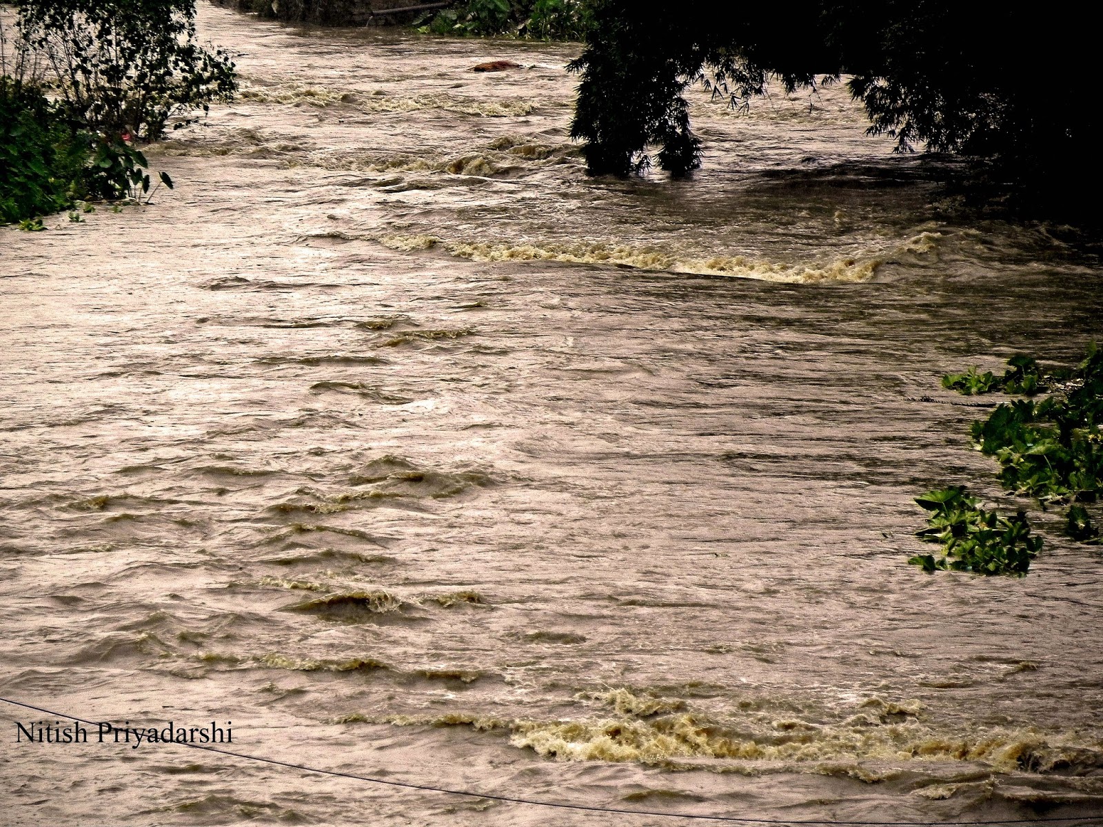
Impact of Phailin cyclone in Ranchi city of India.


Rivers were overflowing and trees were uprooted.

By

Dr. Nitish Priyadarshi.

Heavy rains on Sunday (13th Otober) lashed Jharkhand following the "peripheral effect" of cyclone Phailin. The peripheral effect following Phailin that lay centred in Odisha began in Jharkhand since early morning with heavy rains lashing several districts of the state.74.6 mm rain was recorded in Ranchi till 8.30 am. Phailin entered Jharkhand on Sunday around 4am causing heavy rainfall and recorded wind speed of up to 40kmph. Ranchi recorded 117mm rainfall from Sunday 4am till Tuesday morning. Most of the small rivers of Ranchi like Harmu River, Jumar River, Potpoto River, River flowing under the Over bridge etc. were overflowing due to heavy rain in the city. Even many of the local ponds were overflowing. Trees were uprooted and low land area faced water logging.  

Pictures below show the some of the impact of Phailin in Ranchi city. 


                  Clouds gathering on evening of 12th October.


                Trees uprooted due to storm and heavy rain.

                                 Trees uprooted in busiest road of Ranchi city.


                                          Empty road.

                                                       Overflowing pond.


                                            Overflowing river.


Thursday, September 19, 2013

Chemical Warfare is another threat to the environment.

Its impact is nearly everlasting.

By

Dr. Nitish Priyadarshi

Earlier it was controversial report of use of the Depleted Uranium where thousands and thousands of people, including many children, died after the war in Bosnia from the use of depleted uranium projectiles. Completely healthy people who have lived or are still living in locations were targeted missiles out of the blue they got cancer or leukemia and after a longer or shorter disease died. Depleted uranium has been used in at least the last four wars Gulf War 1, Bosnia and Kosovo in the Balkans, Afghanistan and Gulf War 2. The last two of the four wars, took place in 2001 (Afghanistan) and 2003 (Iraq).

Now the latest news is about use of other weapon of mass destruction on the humans. According to UN report there is “clear and convincing evidence” that chemical weapons were used in the August 21 attack in Syria. The conclusion is that chemical weapons have been used in the ongoing conflict between the parties in the Syrian Arab Republic, also against civilians, including children, on a relatively large scale.

The environmental, chemical and medical samples collected provide clear and convincing evidence that surface-to-surface rockets containing the nerve agent Sarin were used in the Ghouta area of Damascus.
The report said surface-to-air rockets containing the nerve gas sarin were used in Ein Tarma, Moadamiyan and Zamalka in the Ghouta area of Damascus. It does not say which parties in the conflict used the weapons.
Rockets and fragments were found to contain sarin. Several surface-to-surface rockets capable of delivering significant chemical payloads were identified and recorded at the investigated sites.

Close to the impact sites, in the area where people were affected, inspectors collected 30 soil and environmental samples — far more than any previous U.N. investigation — and in a majority of the samples, "the environment was found to be contaminated by sarin," its by-products, and "other relevant chemicals, such as stabilizers."

Blood, urine and hair samples from 34 patients who had signs of poisoning by a chemical compound provided "definitive evidence of exposure to Sarin by almost all of the survivors assessed."
Sarin,  is an organophosphorus compound with the formula . It is a colorless, odorless liquid, used as a chemical weapon owing to its extreme potency as a nerve agent. It has been classified as a weapon of mass destruction in UN Resolution 687

Sarin can be lethal even at very low concentrations, with death following within one minute after direct ingestion due to suffocation from lung muscle paralysis, unless some antidotes, typically atropine or Biperiden and pralidoxime, are quickly administered to a person. People who absorb a non-lethal dose, but do not receive immediate medical treatment, may suffer permanent neurological damage. Like other nerve agents, sarin attacks the nervous system by stopping nerve endings in muscles from switching off. Death will usually occur as a result of asphyxia due to the inability to control the muscles involved in breathing function.

There are so many issues facing the world today that it is sometimes hard to understand why they occur and what they affect.   Today it is apparent that many people take the environment of the earth for granted.   Pollution, energy, and natural resources are all seen as an environmental element that can threaten our future and destroy the environment.   But there is another threat to the environment that is certainly overlooked by today's society and was overlooked by many in the past.   This element is the act of war.   There are many different aspects of war that can affect the environment and the people of our world, but there is one specific facet of war that could be considered most detrimental… chemical warfare.   "Chemical warfare is warfare (and associated military operations) using the toxic properties of chemical substances to kill, injure or incapacitate the enemy" (Chemical Warfare). Chemical weapons can be widely dispersed in gas, liquid and solid forms and may easily afflict others than the intended targets. Nerve gas and tear gas are two modern examples.  But not only does it leave its mark on society and the people of the world, chemical warfare can destroy the unique qualities of nature as well.   The practice of chemical warfare dates back to 1000 B.C and is still used today.   Its impact is nearly everlasting, but still so many people are uneducated on its effects. These weapons kill everyone in any environment where they're deployed. Historically, chemical weapons are inhumane and a horrific way to die—and that's why the most of the world has outlawed them. Chemical warfare is a critical issue of today's society and needs to be dealt with because of its severe impact on our environment and the people of the world.

Earlier one case of such disaster was reported from Vietnam War where approximately 19 million gallons of Agent Orange were used by the US military in southern Vietnam between 1962 and 1971. An aggressive herbicide which defoliates trees, it was used on a large scale in Vietnam’s jungles to enable US troops to spot Communist troops more easily. It eradicated around 15% of South Vietnam’s vegetation, and gave rise to serious health problems for the soldiers, civilians and local wildlife that were exposed to it. Agent Orange contains dioxin, a highly toxic substance that is still detected in the bodies of Vietnamese people today. It contaminated the soil and rivers and, through the food chain, passed into fish - a staple of the Vietnamese diet.

Depleted uranium (DU) is easily ingested by humans because it turns into radioactive dust on impact. As a result, hundreds of thousands of civilians and soldiers have been exposed to a highly toxic, radioactive substance and have suffered the numerous effects of this. In fact, the World Health Organisation suggests that young children in particular are at great risk because “typical hand-to-mouth activity of inquisitive play could lead to high DU ingestion from contaminated soil.” At least 600,000 pounds of DU and uranium dust were left in the Middle East after the Gulf War. With a half-life of 4.5 billion years, the health effects of DU will be a long-term problem.
CW can have very different effects on health. They are grouped in four categories:
1.      Blister Agents (cause severe skin, eye and mucosal pain and irritation as well as burns)
2.      2. Nerve Agents (disrupt the mechanism by which nerves transfer messages to organs and may lead to death by asphyxiation as control is lost over respiratory muscles)
3.      Choking Agents (cause a build-up of fluids in the lungs which then leads to suffocation)
4.      Blood Agents (affect the body by being absorbed into the blood and cause death      in a matter of minutes through respiratory failure)

The Issue of Depleted Uranium (DU) and Chemical weapons are extraordinarily important. It represents a clear threat to the health of all humanity, and all life forms on planet Earth. Scientists, medical professionals, war veterans, active duty personnel, international lawyers and the global human community must call for awareness of this crisis and simply to stop the use of weapons of mass destruction, in order to preserve life on the planet.

Reference:
http://www.ipb.org/web/index.php?mostra=content&menu=Weapons%20and%20their%20impacts%20on%20communities&submenu=Chemical%20Weapons
http://news.nationalgeographic.com/news/2013/08/130828-chemical-weapons-syria-attack-military-action-science-world/

Saturday, September 14, 2013

Geological evidences of ancient glaciation in Jharkhand State of India.


Permo-Carboniferous time, about 300 million years ago, was a period of great glaciation.
By
Dr. Nitish Priyadarshi
Geologist


The Earth has a history of climate change. There have been ice ages and super-volcanoes and with them came evolutionary changes in many of the Earth’s inhabitants;

A glacial period (or alternatively glacial or glaciation) is an interval of time (thousands of years) within an ice age that is marked by colder temperatures and glacier advances. There have been five known ice ages  in the Earth's history, with the Earth experiencing the Quaternary Ice Age during the present time. Within ice ages, there exist periods of more severe glacial conditions and more temperate referred to as glacial periods and interglacial periods, respectively. The Earth is currently in an interglacial period of the Quaternary Ice Age, with the last glacial period of the Quaternary having ended approximately 10,000 years ago with the start of the Holocene epoch.

The Permo-Carboniferous refers to the time period including the latter parts of the Carboniferous and early part of the Permian period. Permo-Carboniferous rocks are in places not differentiated because of the presence of transitional fossils, and also where no conspicuous stratigraphic break is present.

Permo-Carboniferous time, about 300 million years ago, was a period of great glaciation. The widespread distribution of Permo-Carboniferous glacial sediments in South America, Africa, Madagascar, Arabia, India, Antarctica and Australia was one of the major pieces of evidence for the theory of continental drift and led ultimately to the concept of a super-continent, Pangaea. Glacial activity spanned virtually the whole of Carboniferous and Early Permian time . Toward the end of the Carboniferous, around 290 million years ago, Gondwana, the southern part of Pangaea, was located near the south pole. Glacial centres expanded across the continents, producing glacial tillites and striations in pre-existing rocks.

The Late Carboniferous and Early Permian period was an exceptional phase in the earth’s history when the precursors of the modern continents were assembled in the form of two big landmasses (Gondwana and Laurasia) which were connected to form a supercontinent (Pangaea) such that the major part of the land area was in the southern hemisphere. Since the Earth’s climate is dependent on land and ocean distribution, the global air circulation and climate were radically different from the present.


Past Glaciation evidence in Jharkhand State.


Rocks of glacial derivation are limited to the Talchir Formation at the base of Gondwana supergroup. The Talchir, all over Peninsular India comprises a variety of rock types including diamictite (tillite), conglomerate, sandstone, laminated varve-like shale-siltstone (rhythmite facies), and locally turbide deposits. The maximum known thickness is seldom in excess of 300 m.

The sediments comprising the Talchir Formation contain records of a chain of events caused by the climatic evolution during the Carboniferous–Permian boundary period in India. The occurrence of a boulder bed derived from a glacial moraine at the base of the Talchir Formation indicates presence of glacier ice near the basin periphery. Subsequent occurrence of sandstone–siltstone beds and their sedimentary features signify evolution of a large water body. Different research work suggests that the water of this basin was supplied by melting of the glacier. The glacier later retreated far from the lake margin when sediments were carried by melt-water streams.

This development marks a relatively rapid warming episode, which reached a climax when waves generated by intense storms created hummocky cross-stratification in the sedimentary layers. Several Gondwana basins in east-central India recorded this climatic transition in the basal part of their sedimentary sequence typified by the Talchir Formation. The warming initiated during late Talchir continued for a geologically long time with substantial melting of ice in various regions leading to increase in sea level as evidenced by signature of marine transgressions (at Umaria, Manendragarh and Daltonganj). This chain of events finally culminated in occurrence of widespread vegetation and swampy land, which formed the massive Permian coal deposits of eastern India.

Damodar Valley basin in Jharkhand State contains a chain of sub-basins containing a complete stratigraphic sequence of Talchir sediments(Ghosh and Mitra,1975). An excellent exposure occurs near the confluence of Dudhi Nala, Dube Nala, and Silai Nala about 0.5 km south of the village Jarwa  in the western part of the Bokaro sub-basin.

East Bokaro coalfield:

The East Bokaro coalfield ranks third amongst Indian coalfields in the respect of coal potentiality. The name of the Bokaro field was given by D.H. Williams in 1846-47 as the Bokaro river flows through the field for nearly 40 km.

The Talchir formation crops out only in the north-eastern periphery around Chapri. The Talchir formation has its base the typical tillite, which crops out in the nala (rivulet) south east of Lakarkatwatoli village. The tillite is practically unstratified and devoid of sandy interbands. It usually attains a thickness of 2m to 3m. the till favbric study in the Chapri area indicates that the inflow at the dawn of Gondwana sedimentation was from WNW to ESE. It is therefore evident that the Precambrian upland lying to the north of East Bokaro coalfield was the main gathering ground of ice.

Because of the restricted distribution of Talchir beds in the vicinity of Chapri it is surmised that only one major lobe of ice advanced into the eastern periphery of the coalfield.

West Bokaro coalfield :

The base of Gondwana sequence is marked by a thick pile of glacial and periglacial deposits of Talchir Formation. The Talchir beds are well exposed in the western part of the coalfield to the east and northwest of Mandu in Hazaribag district and also occur as a lenticular patch north of Tapin. The Talchir formation comprises diamictites, sandstones, shales, turbidites and rhythmites, which are all typified by a khaki green colour. This section lies at a distance of 68 km, from Ranchi. The area of study lies at a distance of nearly 3 km from Mandu, off the west side of the Dudhi bridge.

Characteristic features of glacial transport are observed in the forms of polished and striated boulders. Unsorted nature of the deposit also suggests their glacial origin.

Ramgarh Coalfield:

The Talchir rocks are best developed in the northern part of the basin around the Barki Punu. A narrow strip of such rocks is also exposed all along the eastern periphery of the basin where good exposures are present in the Bhera river near famous Rajrappa temple.

Till fabric analysis of the basal tillites in the Barki Punu area has indicates glacial transport from WNW to ESE which is compatible with ice flow directions from equivalent horizons in the adjoining Karanpura and Bokaro basins (Ghosh and Mitra,1975).

North Karanpura Coalfield:

The North Karanpura coalfield which is the western most member in the east-west chain of the Damodar valley basins forms a large expanse of coal bearing sediments spread over Hazaribag, Ranchi and Palamau districts.
Talchir formation is exposed along the fringes of the basin in the north, east and south. Tillite which is dumped type deposit comprises out sized clasts, which vary in size from a few centimeters to a few meters.

The different occurrences of the tillites indicate that they were laid down by different lobes of valley glaciers as abalation till or lodgment till rather than by a continuous ice sheet (De, !980).

Glacial pavements with undisputed glacial striae indicating ice transport from north and NW has been reported from the north of Pakri Barwadih at the northern margin of the basin ( Chakraborty and Bhattacharya, 1973).

Auranga Coalfield:

Auranga coalfield is the easternmost of the North Koel valley Gondwana basins. It is only 8 km away from the North Karanpura basin, the westernmost of the Damodar Valley coalfields.

The Talchir formation in Auranga basin has a maximum thickness of 30 m to 35 m. It is evident the ice had moved from the southern uplands and deposited the morainic material in bedrock depression. From the distribution pattern and their facies organization, it can be concluded that several lobes of ice had reached this basin and deposited glacial and fluvioglacial sediments in the bedrock depressions.

Hutar coalfield:

The Hutar coalfield is the westernmost of the Damodar-Koel valley Gondwana basins. It is one of the four coal bearing areas in Palamau district of Jharkhand.

The Talchir sediments in this area exposed along the northern, south eastern and southern boundaries of the Hutar basin and they crop out as narrow strips. Good exposure of Talchir rocks are observed in the section of nalas (rivulets) like the Saphi nala near Unkamanr, the Deori nala west of Barwadih and near Paisartanr, the Baheradhora nala, the Thongwa nala, tributaries of the Saphi nala around Nawadih, the Jamtipani nala and its tributaries and a tributary of the Jharna nala.

An analysis of till fabric, primary directional structures and lithofacial distribution indicates that the direction of glacial transport was mostly towards  north and north-east. Though no sub-surface information is available, total thickness of the Talchir formation is estimated to exist 50 m.

Deoghar Basins:

Extensive exposures of Talchir rocks are noted all along the southern margin of Jainti basin. The formation also covers a large area along the northern boundary of the Saharjuri and Kundit Kuraiah basins. In addition, more detached outliers of sediments have been recorded in the vicinity of Makranda, Alaura, Alakbera, Darabandh, Satuabad and Burhai. These occurrences of Talchir outliers testify to widespread glaciation in the Deoghar area, the detached outliers being erosional remnants.

Reference:

Chakraborti, S.K. and Bhattacharya, B.P. 1973: A note on the occurrence of glacial movements along the northern boundary of North Karanpura coalfield, Hazaribagh district, Bihar, Jour. Geol. Soc. Ind. 14(3).

Coal Resources of Bihar, 1987.  in Bulletins of the Geological Survey of India, Vol IV (part -1).

De, A.K. 1980: Lithology and conditions of deposition of Talchir Formation in North Karanpura Basin. Jour. Geol. Soc. Ind., Vol.21, 593-602.

Ghosh, P.K. & Mitra,  N.D. (1975): History of Talchir sedimentation in Damodar Valley Basins, Mem. Geol. Surv. Ind.,105.